 This morning begin with some rain, then overcast and generally damp until about 1pm -- typical English weather. The forecast was for sunny and warm (70's) by 4pm, so I headed up to Ennerdale Water and started my hike at 4pm sharp. The weather guessers got it right!
Ennerdale is about 30 minutes away (10 miles as the crow flies) because the most direct route is via a fell road from Calder Bridge to Ennerdale Bridge. 30 mph is a safe speed as you dodge sheep and other cars along winding lanes that are only about 8 feet wide. Every 100 meters or so is a passing area, which is to say the road widens to 2 lanes for about the length of a car! Okay, the idea is you pull over and let the oncoming car get by. The drive alone was worth the trip, it is beautiful and when Suzanne is here I'll take her through to see the lambs and take some pictures.
There are actually fell trails up there for walking...I may have to investigate them some Saturday...

That's Crag Fell. You can see a couple of the trails on the lower left of the fell, plus there is one that goes through the woods just to right of center. That's the route I took.
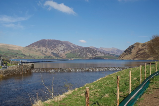
Ennerdale Water is at 110 meters. It's not a large lake, and there are trails that lead all the way around it. There were quite a few folks walking around the lake.
At this point, I wasn't sure which trail was which, my guidebook basically says to walk along the lake, pass through a gate and turn right (for trail number 2) and follow a stone fence until you get to an opening in the woods. Then follow the switchbacks up the fell until you can ford the stream towards the left. From there (per the guidebook) it's an easy hike up the fell along a ridge past Revelin Crag and Cragfell Pinnacles.

So find the stone fence and follow it to the wooded area. Then look up at the trail…

Hmm, somethings wrong here! There's not much of a trail, and I don't see any switchbacks. Ah, there they are along the fence to the right. Not so much switchbacks as steps people have created as they walked up. Oh well, up I go. It's not that high, so how hard can it be?
Well, it was freaking very hard!
After about 50 meters up I was huffing and puffing. Then it got steeper…and steeper…and steeper. I was going up more than going forward.

Occasionally I'd turn around (and nearly fall over it was so steep!) But I had to stop and take this shot. As Ann says, these are European Larch trees. A hardwood conifer that is deciduous. I always thought deciduous trees were evergreens, as I thought conifers were evergreen. But these lose their needs in the fall.

After a while (okay 30 minutes of hard climbing) it got less steep (certainly NOT flat) and as I rounded this outcrop I decided to take this picture.
As the guidebook says, I crossed the stream, below it was pretty wide and with lots of water, up here it was about a foot wide! The trees were now below me and I looked up and could see Crag Fell directly.

At this point I'm about 45 minutes up, and the earlier part of the climb had killed my legs. So every 25 meters or so I stop to catch my breath. Up and up I go; from here it's about 200 meters vertically more to the top.

What a great view! This is looking east towards the upper end of the lake.

Gratuitous shot of me at the top.

After 30 minutes of rest, some hot tea, water (of course) an apple and some trail mix I was ready to head back down. I decided to take a different route down (trail number 3 I'd hoped, but it was not to be). I came by Cragfell Pinnacles and took this shot, it feels as though I'm looking straight down. There is actually a trail down to the Pinnacles but I wasn't sure where the trail led from there…and I did NOT want to have to climb back up to this one!

As I came down, this just looked like a Kodak moment. You can see the trail coming from the lower right.

Another pretty shot looking back up the fell.

And another…

And finally, over to where my car is, off to the left, just before that building. If you can spot it…the weir (falls) from the top photo above is in the lower center of the picture.
Crag Fell. 4 miles. 413 meters up from the lake level. 3 hours.
Until next time...
No comments:
Post a Comment